Describing the area as "the fairest picture the whole earth affords," Mark Twain, commented in 1861.
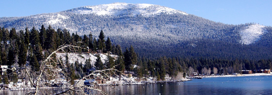
Among the world's most beautiful alpine lakes, Tahoe is too close to the largest metropolitan regions in the country. This adds to its own peculiarly vulnerable situation exacerbated by a 40,000 population with some remarkable density measures for a high altitude terrain. Cities or suburban sprawl surround most of the lakeshore creating consequences with respect to soil erosion, pollution laden runoff, diminished water clarity, and changes in thermal capacity. At 1898 meters [nearly 6,228 feet] in elevation encased within the western and eastern crests of the Sierra Nevada mountains Lake Tahoe is a defining element in the landscape. The terrain of the Tahoe drainage basin marks an oasis in an otherwise montane desert and a forest domain in the midst of extensive arid scrub lands.
landscape | physical | population | impacts | details | location
"Thus by the early 1970s, agencies of the federal and state governments owned more than 70 percent of the land in the basin, a total that reached 85 percent in the next two decades."
The ironic effect of the land purchases was to press more numbers of people into a smaller area of land and thus increase their impact on the south shore of the lake, leading to both a loss of wetlands and a growth in marina development. South Lake Tahoe population began to slow the rate of increase in the 1980 to 1990 period to only one percent in the decade. (Strong. p. 99.)
According to the census "the United State's most densely populated urbanized area is Los Angeles-Long Beach-Anaheim, California, with nearly 7,000 people per square mile. The San Francisco-Oakland, California, area is the second most densely populated at 6,266 people per square mile, followed by San Jose, California (5,820 people per square mile) and Delano, California (5,483 people per square mile). The New York-Newark, N. J., area is fifth, with an overall density of 5,319 people per square mile." [US Census. 2010]
Douglas H. Strong, historian, notes that "nine million people live within a four-hour drive of the lake and that local tourism will inevitably continue to dominate the lake's economy, adding to traffic congestion and pollution." (p. 100.)
For a rural enclave beside a wilderness designated region the Lake Tahoe basin ranges from 2100 people per square mile to under 38 people per square mile. Nearly 50,000 permanent residents crowd the steep slopes lining south and north shores of the lake and accounts for the degradation of the area's waters, forests, wetlands, fisheries and wildlife.
A consequence of the concern from the 1960s was scientific attention to the physical conditions of Lake Tahoe [a word meaning lake in the native Wa shoe language].
"Studies on the physical limnology of the lake have included weekly to monthly temperature profiles since 1969, with surface measurements from 1964. These data afford an opportunity to examine long-term trends in the lake’s thermal structure, and to relate trends to possible driving climatic variables."
impacts | drought | census | consequences | water quality | effects matrix
In 1990s the forest of the Tahoe basin were subject to drought.
"Unfortunately, the forests of Tahoe faced a crisis caused by an extended drought. In 1991 the Forest Service reported 300 million board feet of dead timber within the basin. Probably 25 percent of Tahoe's forest had died–s much as half in some areas."
"...a healthy forest depended on 'healthy, diverse communities of plants, animals and fish.' The group adopted 'ecosystem management' as its guiding principle. The se ideas emanated from the writings of an American forester and environmentalist, Aldo Leopold, who defined land health as 'the capacity of the land for self-renewal' and conservation as 'our effort to understand and preserve this capacity.'
According to a recent ecosystem study at Tahoe, the challenge of ecosystem management is to sustain systems that are diverse, productive, resistant to short-term stress, and abe to respond in a healthy way to long-term change.' To achieve such goals depends on understanding the ecological role of those who came before, including the Washoes, and the nineteenth century Euro-Americans."
pp. 90-91.
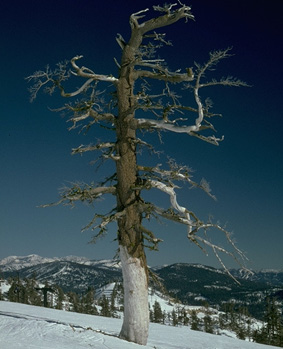
"Under natural circumstances, frequent fires clear out underbrush, and leave a more varied forest, less susceptible to the impact of disease, insects, drought, and fire. Now, however, the dieback has created severe fire hazard in which any small fire hazard in which any small fire can turn into an unstoppable firestorm, destroying the vegetative ground cover and unleashing massive soil erosion into the lake."
pp. 92-93.
Douglas H. Strong, Tahoe: From Timber Barons to Ecologists. Lincoln: Nebraska, Univ. of Nebraska Press. (1984-1999).
impacts | drought | census | consequences | water quality | effects matrix
The 2010 census further revealed:
"Of the 10 most densely populated urbanized areas, nine are in the West, with seven of those in California. Urbanized areas in the U.S., taken together, had an overall population density of 2,534 people per square mile.
The New York-Newark area continues to be the nation's most populous urbanized area, with 18,351,295 residents."
Of the 3000 counties in the US, 3,573 metropolitan or urban areas accounted for 80. 7 per cent of the nation's 308,745,538 people. Three counties divide the jurisdictions of the Tahoe basin complicated land use regulation and taxation to support urban services.
10,448 is the total population of the Lake Tahoe urban cluster on north shore of the Lake, but there are 12,106 housing units there. This is the more steeply sloping shore worn by glaciers, ice and snow.
More people crowd the south shore of Lake Tahoe 22,114 residents in 2008-2010 studies. Along this shore the gently sloping alluvial plains and terminal moraines are crowded terrains where the loss of wetlands is extensive.
"Los Angeles-Long Beach-Anaheim is the second most populous (12,150,996), followed by the Chicago area (8,608,208). These areas have been the three most populous since the 1950 Census, when urbanized areas were first defined; however, at that time, Chicago was the second largest. Los Angeles became the second most populous urbanized area in 1960, and the order of the top three has not changed since."
The impacts of population on the Tahoe basin are not hard to discover. C. Elizabeth Raymond has written "The physical alteration of the Tahoe landscape has been extensive, as the photographs demonstrate. The modern terrain is an artifact, created by almost 150 years of active human intervention in the basin."
"Nature had endowed Tahoe (a Washoe word signifying lake) with substantial assets to be exploited. The lake itself was a giant reservoir in the midst of a desert. It was surrounded by enormous stands of timber in a generally treeless land, adjacent to both a mining area and a railroad, each of which had an insatiable appetite for wood."
"A Place One Never Tires of': Changing Landscapes and the Image at Lake Tahoe." in Peter Goin, Stopping Time. Albuquerque: University of New Mexico Press, 1992. pp. 12-13.
impacts | drought | census | consequences | water quality | effects matrix
The impacts of population pressure and industrial consumption in the Tahoe regional area have been documented, too, by the U. S. Forest Service and reveal direct and indirect as well as immediate and lon-term consequences of too many people pursuing hyper-industrial recreation. Since the late 1950s concerned groups calling for improvement and conservation of the Lake estimated that on busy summer weekends in the 1960s 150,000 people crowded the lake shore. Cars were the principal means of travel to and from the basin adding to the nitrous oxide and smog pollution of the air and water in excess of what increasing population density does to the forests and watershed of the region.
What did this synergy of people, transportation, and habitation pressures do? The Forest Service maintains that "Links with ecosystem health, resource conservation (vegetation, soil, and water), and biological diversity are central to the health of Lake Tahoe. The white pine species – whitebark (Pinus albicaulis), western white (Pinus monticola), and sugar pine (Pinus lambertiana) are important components in low to upland forest communities. Interactions among anthropogenic disturbances such as historical logging and fire suppression, an exotic pathogen (Cronartium ribicola), cause of white pine blister rust [WPBR]), and climate-driven outbreaks by Dendroctonus ponderosae (mountain pine beetle) have significantly affected populations of white pines in lower montane, upper montane and subalpine forests.
White pine blister rust is one of the greatest threats to white pine sustainability and survival. In the Lake Tahoe Basin this invasive pathogen is significantly affecting recruitment potential and survival of small and intermediate-sized trees. Such adverse demographic effects can have long-lasting consequences on population structure and dynamics. Comstock era logging, in some locations, has reduced effective population numbers and genetic variation of sugar pine.
Both influences (i.e., WPBR and historical logging) can significantly affect how these species respond to other stressors, such as global climatic change. Strong evidence of negative population and genetic effects warrants white pine restoration in the Lake Tahoe Basin. Mitigating anthropogenic influences will require restoring effective population numbers, deploying WPBR-resistant material, ‘facilitating’ recruitment, enhancing genetic variation, and planting drought-tolerant genotypes."
The United States Department of Agriculture: Tahoe Science
Update Report
Prepared by: Tiff van Huysen
Tahoe Science Program Coordinator
USDA Forest Service-Pacific Southwest Research Station
impacts | drought | census | consequences | water quality | effects matrix
Forest disturbance due to:
• historical logging,
• fire suppression,
• an exotic pathogen,
• pine bark beetles.
Vegetated landscape is not unlike skin, without it the organism dies; as such the land organism goes into terminal shock from which it never easily, nor fully recovers.
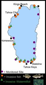
Predicting and managing changes in near-shore water quality
Conditions in the near-shore zone of Lake Tahoe have degraded owing to the establishment and spread of invasive fishes and aquatic plants, and increased concentrations of periphyton (attached algae) on rocks, piers, and other hard substrates.
The near-shore zone suffers pollution from marinas and accidental spills. Consequently, management strategies to improve clarity in the middle of the lake will not necessarily improve conditions in the near-shore zone. This research will improve understanding of these processes to help develop scientifically sound management strategies and thresholds.
United States Forest Service, partnership
habitation refers to the combined influences (impact) of the footprint on the location of a structure (area occupied), altered run-off of snow and rainwater, the necessity for electricity, municipal water supply, and sanitary sewers, or septic tanks, roads and snow removal.
Categories of impacts on alpine lakes TYPE direct indirect immediate nitrogen run-off algal growth persistent diminished light at depth oxygen decline Under the clean water act there are six measures of water quality include: turbidity (clarity), dissolved oxygen [DO], nitrogen [N], phosphorus [P], biological oxygen demand [BOD] and fecal coliform levels. In addition, both temperature and pH (acidity vs alkalinity) are necessary measures of water conditions that determine the quality of any place.
impacts | drought | census | consequences | water quality | effects matrix
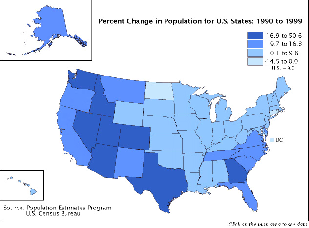
Change in population 1990s in percent; darker blue is fastest growing areas.
![]()
1-D
3.2808399 feet equal a meter.
so 1898 X 3.2808399 = 6227.04 feet.
![]()
2-D
87120 square feet in two acres means that
an acre = 43560 square feet.
an acre is also .404685642 hectares
![]()
3-D
99 people per day die in automobile accidents for over sixty years.