What is the
tragedy of a short sighted view?
by Joseph Siry
It is easier to see the immediate obstacle, say ahead of you
on a river, or roadway and look at the scenery of forests and sand hills, than
it is to see that the way in front of you is attached to something even deeper,
beyond the scenery. The stream or roadway is always attached directly and indirectly
to the warp and woof of the land. That means the road or path must move up and down, around obstacles.  Features like creeks, rivers and trails are
all parts of a larger entity, the landscape. The term landscape is derived from
the Dutch word referring to the terrain, or the shape of the area where topography
and water conspire to create meaningful places for humans to habituate if not
to inhabit.
Features like creeks, rivers and trails are
all parts of a larger entity, the landscape. The term landscape is derived from
the Dutch word referring to the terrain, or the shape of the area where topography
and water conspire to create meaningful places for humans to habituate if not
to inhabit.
Landscape is inescapably bound up with fire and water, radiation
and rain, vegetation and animate life. As the water falls across any region
it gathers in ponds, lakes, rivers and creeks as it sculpts the hills and plains
of any topography--that is the surface of the earth. We are all attached to
these streams and the fabric of water and land knits us tightly into the unraveling
framework of the world. The world is unraveling because as time passes the power
available for living things to seek shelter, nourishment and security diminishes.
This is a cosmic law of entropy that cannot be repealed, only modified to assure
our momentary survival. How well we negotiate with entropy determines whether
we flourish, or perish. Life is simple at this material level, either acquire
sufficient nourishment, or cease existing. Either learn how to fish, acquire
clams, oysters and mussels, or grow in hunger, weaken your responses and slowly
become food for other living beings. There is no escape, adapt and you avoid
entropy for a while, resist and the cold stream of life devours you.
There is a story in every river and it is often the same. Rivers bring an opportunity to the land and its creatures either learn the lesson the
river has offered the animate beings, vegetation and features of the landscape
or ignore these gifts and die with the effortless ebbing of the eternal tides
that draw river's ever homeward to their birthplace in the sea.
The moral of this story is that: Real
things we hold in common must not be traded for the short-term benefit when
faced with a staggering long-term costs.
Thames
Barrier | Rivers | WEAL
as a system | Sea Level rise | History
| tides | Diagram | Photographs
| Map | Conclusion
Landscape is the product of dependent cycles represented by
the word “weal.” A river-scape is a landscape shaped by and adjacent
to a river system and its tributaries. Rivers carve the surface and submarine
depths of the land, or the geological formations through, over, and around the
places where runoff and streams flow.  The
topographical area over which the rain falls and runs off into the same river
is referred to as a watershed. The Thames watershed is over ten
thousand kilometers square, or 3,860 square miles. Over 3000 people per
square mile live in the watershed and municipal London -- with even a greater
number of residents-- is among the most densely populated areas on Earth.
The
topographical area over which the rain falls and runs off into the same river
is referred to as a watershed. The Thames watershed is over ten
thousand kilometers square, or 3,860 square miles. Over 3000 people per
square mile live in the watershed and municipal London -- with even a greater
number of residents-- is among the most densely populated areas on Earth.
Systemic thinking about the Thames river in terms of water,
energy, air, and landscape is symbolized in “weal”
as an acronym that reveals related scientific and social consequences to altering
rivers. For example, when tidelands are drained flooding is an inevitable risk
due to water displacement; subsidence of the ground only exacerbates the risks
associated with increasing the flood’s extent. Floods increase in extent
when channels are clogged with silt, sediment and debris. The extent of a floods
impact increases as forests are timbered upstream and wetlands are drained adjacent
to the flood plain. With less space for the water to flow during excessive volumes,
the water floods out over the landscape. The movement of silt and sediment in
a river is greatest at flood stage.
WEAL
- is an acronym for the parts of a habitat that regenerate ecological integrity.
Literally “weal” derived from weald meaning a forest (root of wealth)
is figuratively used to refer to the cybernetics (feedback control systems)
of water, energy, air, and landscape in systemically fostering ecological conditions
of a place. As rivers are re-engineered to meet industrial and agricultural
demands, the natural features of upland forest, riparian wetlands, springs,
lakes and the underground water table all become more, and not less significant
to the health of the river's water for fisheries, wildlife and human consumption.
The Thames is a convenient case study because the river constricts as it reaches
London, where the estuary and the upland converge at a place where the Romans
first built a settlement to cross the river nearly two millennia ago.
Water
Thames’ waters drain southeastern England from the Chiltern Hills to the
North Sea on the eastern extreme of the country, or approximately 10,000 sq.
km.. Over 12 million people depend on London for a living or place to live.
Sea level rise during the last 50 and 100 years is accelerating affecting the
mouth of the 340 km. long river. Thames’ water rises nearly a meter/century.
Sea level globally has been measured, on average to be increasing
at 8 inches per century due to the thermal expansion of the oceans. The rate
is accelerating and may double by 2100 according to the Intergovernmental
Panel on Climate Change.
Energy
Tides on the Thames have been critical to human existence, geophysically, biologically
and socially. Trade and transportation focus on this narrowing of the river
as it carves out the northern bank near where the tide ends. Here in 43 BC Roman
soldiers and slaves constructed Londinium , beneath the site of contemporary
London.
Above London, upstream on the Thames, the tide ceases to have a useable quality
for it barely even ebbs at all. At Tedington [tide + ending + town] the down
stream flood of the fresh water forces the Thames current against the observable
flood and ebb currents of the tides.
Human alteration of the Thames rests on the capacity of institutions
to use electrical energy to utilize resources and alter the landscape by so
doing. According to UK's
Environment Agency, the Thames is home to:
- Effluent discharge consents - 9,018
- Major Industrial Processes - 135
- Sites using radioactive materials - 274
- Nuclear Sites - 7
Atmosphere
London suffers from climate change: the global greenhouse gas emissions debate
is over how fast Carbon dioxide gas [CO-2] in the atmosphere is increasing.
|
Atmospheric change is attributed to human activities [anthropogenic] and
measured by CO-2 sources.
|
| |
But, is CO-2, or carbon dioxide |
|
| a lagging, |
a tagging, |
a triggering, |
a preceding, |
|
indicator of temperature (heating of the
lower atmosphere) change?
|
Weather
Acid Rain due to cars and coal burning electrical plants create sulfuric emissions.
Drought and rain cycles distribute emissions and drive ecological cycles Variance
of the heat transfer from tropics to poles, or storminess, is increasing.
Storm tides on the Thames in 1953, created a flood that killed 300 people.
London’s air contamination December of 1952 triggered over 4000 deaths
and led to restrictions on dirty coal burning. These examples are historic
cases of anthropogenic sources of local air pollution that were corrected
by technological alternatives.
Landscape
Water logged landscape covers an appreciably large portion of the earth’s
land in proportion to the arable (or farmed) acres. Some timber literally stands
in water so that aerial estimate of wet timber as opposed to dry is difficult.
In the Amazon basin adjacent to the river floods for half the year to where
the banks of the river extend to two or three times their dry season width --
inundating vast areas of rain forest in fresh water for three to four months.
The flood plain of a river is always subject to inundation, hence the name of
the geographical feature that differs in size with each valley. The Thames river
has a flood plain area of just under 900 km square (896 km sq.) or 345 square
miles.
When rivers and landscape are thought of together they are
conceived of as drainage basins for rain water to collect from run off. The
entire river basin with its tributary streams is called a watershed. The Thames
covers "5,330 kilometers [km] of main river in the region." The river
officially rises in the Chiltern Hills and until it reaches Oxford is referred
to as the River Isis. From Oxford to its mouth the river is referred to as the
Thames proper. Along its 184 mile traverse of the countryside, the Thames collects
the runoff of streams, creeks and springs from 13,000 square km or five thousand
square miles.
Rivers sculpt the geological basins fashioning watersheds
from he softer bedrock materials of sand, clay, loam or peat remains. The land
is the river’s gift & so are the wildlife. Estuaries are shaped by
sea level rise and by surface drainage from off of or seepage from beneath the
land. Watersheds consist of all lands draining from creeks, streams, rivers
or tributary systems of rivers contributing run-off to into a solitary river,
i.e. :
Thames river into North Sea.
"12 million people live in Thames Region and the number
is rising." according to the UK's
Environment Agency.
In the El Nino year of 2002-2003, the Agency posted the following
warnings:
"There are currently 1 Flood Warning and 9 Flood Watches
in force across the Thames Region. Rainfall across the region since November
has been more than double the seasonal average."
UK's
Environment Agency.
Other important estuaries of rivers:
Susquehanna River into Chesapeake Bay,
Sacramento River into San Francisco Bay,
Everglades into Florida Bay, or the
Hudson River into Upper and Lower New York Bays.
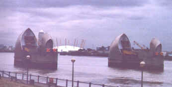 The Thames Barrier against flood waters
From 1974 until 1984, the far sighted British engineering team
constructed a marine engineering work referred to as the Thames
Barrier to protect London from floods.
The settlement of Thames
Valley in the soft chalk hills of southeastern Britain affords a glimpse
of the common cost incurred when vital parcels of the estuarine ecosystem are
altered. For a decade, as many as 4,000 men and women were engaged in the building
the public works project, which cost nearly 500 million pounds. That is about
ten pounds for every person in the United Kingdom. The Thames Barrier cost £500
million and took ten years to construct (1974-1984) with the labor of 4000 people
meaning £50 (fifty million pounds) annually to protect twelve million
residents of the area.
Additional costs with concentrating a quarter of the nation's
people on just a small percent of its land include conservation. According to
the UK's
Environment Agency, "By far the biggest of these other purposes if
flood defense. The region spends about £20 million every year on flood
scheme works. A significant part of that money is devoted to the improvement
or creation of habitats for wildlife."
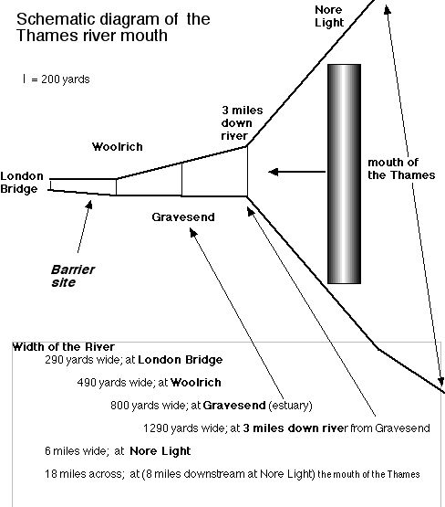
The relative sizes
of the Thames estuary have an extraordinary impact
on the height of the tides. That is because the amplitude of the tides is partially
based on the contours of the basin in which the force of the sea is constricted
as it moves under the forces of the sun and the moons gravitational attraction.
The geology and geography of the submarine basin below the Thames concentrate
waves generated by the tides up a narrowing bed. That constriction of the volume
exaggerates the height and the depth to which the tide water moves every day.
Tidal variation along the North Sea occurs twice daily, meaning there are two
high tides and two low tides every day of nearly equal mass. Amplitude is the
distance between the high and the low water marks left as the tide floods and
then ebbs.
Geography and geology shape the boundaries within which all ecosystems’
biotic inhabitants thrive or perish due to underlying physical conditions of
existence. Geography is not destiny although the present site of London is sinking
in relation to the world around it. Long after our current debates about climate
change end in either certainty or uncertainty the downward tilt of southeastern
Britain under the advancing Alps is certain. Unerringly this downward tilt results
in the upward tilting of Wales, the Midlands, and Scotland with respect to the
Earth’s surface. Lately the city has also experienced the effects of several
centuries of rising sea level with respect to the coast’s mean sea level.
Water rises at the rate of 2.5 feet per century in central London where a density
of 16,000 per square mile exists.
Geologically the southeastern portion of the British Isles is tilted downward
beneath a series of folds in marine rock compressed to form oolite (chalk).
Off the south Florida shore a similar process of the creation of limestone out
of the shallow sea is still occurring.
In Florida Bay oolite litters the quiet sea so shallow as if
a piece of the everglades had been advanced upon by the rising sea. Oolite forms
sediment, compacts into rock and hardens under pressure to form limestone. Under
greater pressure marble forms from limestone after it is metamorphosed by heat
and pressure.
Due to reclamation and drainage the subsidence
of the lands along the Thames exacerbated the natural process that had already
been underway for some period of time, since 1400s. When accompanied by land
subsidence, rising seas accelerate the relative depression of the Thames shoreline
with respect to the sea level. These synergetic causes of flooding placed over
a million people at immediate risk over a forty five square mile area.
 With
rising sea levels the Thames Barrier was constructed and financed by pledge
of Parliament. Faced with flooding, the rotational, tilt and slide mechanisms
of the gates function to successfully control tidal flooding below London. From
the above diagram it is evident that the city is imperiled by the constriction
of flood waters from the mouth of the widening river bed. In addition the river
had been encroached upon by extensive reclamation to the extent of reducing
the width of the river at the site of London. By constricting the volume of
the water in the river, these riverside reclamation projects deprived the Thames
of its historical flood plane. Forcing the same water through a narrower passage
increases both the speed and the height of the flood waters. Both natural and
human engendered alterations of the shoreline left the city of London vulnerable
to flooding more frequently.
With
rising sea levels the Thames Barrier was constructed and financed by pledge
of Parliament. Faced with flooding, the rotational, tilt and slide mechanisms
of the gates function to successfully control tidal flooding below London. From
the above diagram it is evident that the city is imperiled by the constriction
of flood waters from the mouth of the widening river bed. In addition the river
had been encroached upon by extensive reclamation to the extent of reducing
the width of the river at the site of London. By constricting the volume of
the water in the river, these riverside reclamation projects deprived the Thames
of its historical flood plane. Forcing the same water through a narrower passage
increases both the speed and the height of the flood waters. Both natural and
human engendered alterations of the shoreline left the city of London vulnerable
to flooding more frequently.
The Thames Barrier in London is described by the Greenwich
tourist commission as:
"The Thames Barrier has been described as
the eighth wonder of the world. It is certainly a very impressive work of
engineering.
High water level at London Bridge has risen about two and a half feet per
century, due to the melting of the polar ice caps and the activities of
Man. However, the main possible cause of flooding in the London area is
surge tides. These originate in the North Atlantic, and generally pass to
the north of the British Isles. Occasionally, however, northerly winds will
force them down into the North Sea, sending millions of tons of extra water
up the Thames. One and a quarter million people were at risk, spread over
45 square miles."
Thames barrier, like its cousins of marine engineering in The Netherlands and
Italy, is a tribute symbolically of the vision of Francis Bacon that technology
could be used to promote scientific perspectives while solving complex problems.
It is also a common response to a threat to the community financed by the internal
revenues of this public entity.
Changes in the geography of London as it has been sculpted by technology have
had an ironic quality with respect to impact on the city’s form. 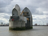
The irony lies in the fact that London is being saved by engineering,
or at least assured of reduced risks, from flooding by the application of marine
technology. The marine engineering in this case is adapted to fit the maritime
vicissitudes of this river valley. The barrier is, in essence, a collectively
funded shield raised up against the onslaught of the rising sea. Since it is
hard to move London to higher ground it was apparently considered reasonable
to protect it by constructing a dam and allow ocean going shipping to pass.
These gates would need to operate in two directions simultaneously should the
need arise. The twin needs of navigation and flood control are creatively satisfied.
The unofficial information sight describes the barrier in some
detail.
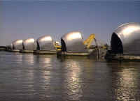
The 1716 feet width of the river is divided by nine
reinforced concrete piers, to form six openings for shipping and four
other openings. The piers are founded on solid chalk, over 50 feet below
the level of the river. The four largest steel gates are 200 feet wide
and weigh 1500 tonnes each. 4,000 men and women were engaged in the building
work, which cost nearly 500 million pounds. In addition, eleven and a
half miles of the river, to the east of the barrier, were protected by
new walls, to a new defence level of 23 feet. New walkways and amenity
areas were created. This further work cost around 100 million pounds.
Similar work was carried out by other Water Authorities, improving the
defenses to the mouth of the estuary.
A brief history of Conservation of the Thames
This barrier on the Thames deflects away storm waves from the densely populated
urban core. The barrier insures the flood control of expensively priced districts
along the commercial stretches and extensive industrial reaches of the Thames
shores.
The Thames was made the ‘conservancy’ of the Aldermen
and Lord Mayor of London in the middle ages for the protection of fisheries,
birds and flows of the rivers tributary to the Thames. Medieval common lands
(marshes & fens) along the shore were breeding places for fish and birds
upon whom people depended for food or occupation. The conservancy was established
to protect those interested in “the need for artificial measures to preserve
those wild species on which people depended for food of sport.”
Protecting these necessary and commonly important areas was inherent in the
duties of the Thames conservancy. *
The Thames Barrier by extension today is an attempt to keep
the rising flood tides from destroying homes, jobs, and lives. For about £10
per citizen the structure provides some protection from seaside floods.
Conclusion:
Natural areas as functional systems are more significant to our health and sources
of wealth than we can know. Had these systems that operate along rivers been
better understood and widely appreciated, London would not be in as grave a
danger from flooding as it is today. This means that the river must be viewed
as a common source of wealth and a single unit. All rivers as a unitary entity
are one source of economic and public health from source to sea. From the forests
and springs of the headwaters to the lakes and wetlands along its course down
to the tidal marshes of the coasts, each natural feature plays a significant,
if puzzling, role in the maintenance of a healthy and smooth flowing river.
Remove one facet of the puzzle of natural features that comprise a working river
and the life of a river unravels.
Had the wetlands been retained or the cut over forests been
replanted, or lost lakes been replaced by reservoirs, and had the laissez
faire approach to ground water pumping not been promoted, London residents
would not have experienced wild fluctuations in the Thames' flow. Each of these
actions in and of themselves damage a river's capacity to meet competing demands.
But when all of these activities are viewed together instead of in isolation
the cumulative impact they have on a river is greater than the mere sum of their
alterations.
Hence the tragedy of a short sighted view is that looking at
only parts of a systematically connected problem is like treating symptoms of
a disease instead of the underlying causes of the malady. In the end the costly
surgery we perform on our rivers today is an out growth of piecemeal and symptom
focused learning. Instead the tragedy of flood or pollution provoked disease
is worsened every time we fail to remedy underlying causes by using adaptive
management.
Currently, London must invest in costly marine engineering
to maintain the health and safety of the river for millions who directly and
indirectly rely on the river to live. Britain has learned what Venice and the
Netherlands have and continue to learn the price of living on and near the sea
is eternal vigilance. That translates into expensive common investments to offset
the damages caused when private investments along the river damage the natural
features that knit a river, a basin and indeed the entire watershed together.
While tectonic forces are undermining the geological conditions of the chalk
valley of the Thames, engineering is now a necessary partner in contemporary
river management, use and redesign.
 *
Keith Thomas, Man and the Natural World, (NYC: Oxford University Press,
1983), p. 276.
*
Keith Thomas, Man and the Natural World, (NYC: Oxford University Press,
1983), p. 276.
Luna B. Leopold, A View of the River (Cambridge,
Ma.: Harvard University Press, 1994).
Peter Casapieri, "Environmental Impact
of Pollution Controls on the Thames Estuary," The Estuary as Filter
(San Diego:Academic Press, 1984), pp. 489-504.
Terms
| Glossary
| Word webs | Basic
vocabulary | Advanced
Vocabulary | Antonyms
| Synonyms
Science
Index | Site Analysis
| Population Index | Global
Warming Index | Nature Index | Brief