San Francisco bay and Delta tributary
system comprises 1,600 square miles.
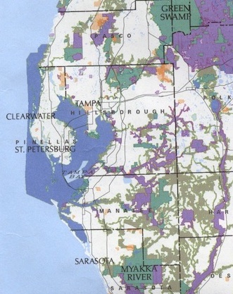 The Tampa bay area comprises 398 square miles.
Tampa Bay is home to 40,000 bird residents and drains one tenth the state of Florida through the Hillsborough (southwestern Green Swamp), Alafia and Manatee rivers. It is shown as dark blue on the map at right.
Geologically speaking the bay was formed by the subsidence of land and the flooding of river mouths by rising sea level after the end of the previous ice age some 10,000 years ago.
The bay area is home to two metro-areas (standard metropolitan statistical areas):
- Tampa
- St. Petersburg
The water area Tampa Bay is a large (water surface area of 1,036 square kilometers, [km2]), shallow region is one fourth the size of the San Francisco Bay and delta system.
San Francisco bay covers an area of over 450 square miles (1,165.5 square kilometers, [km2]) in size and drains half the state of California, including silt and detritus from a 60,000 square mile watershed west of the Sierra Nevada Mountains.
Geologically formed by the tectonic movement of two plates along the San Andreas fault, The San Francisco side of the bay is on the Pacific plate moving south and to the east, while the opposite shore (East Bay, Contra Costa and Alameda counties) is moving to the north and west along the edge of the North American plate. Movements along this fault system triggered the great earthquake here on April 18, 1906, at 5:12 AM, killing 3,000 people and leaving nearly 400,000 without services, if not half that number having been made homeless.
See pictures at the National Archives of the 1906 disaster.
The bay area has suffered a 95% loss in its wetland acreage since 1850.
home to three metro-areas (standard metropolitan statistical areas):
- San Francisco/San Mateo,
- Oakland, or East Bay
- San Jose, Santa Clara