
 Floods
Mark Fischetti, October 1, 2001.
"Coastal marshes are disappearing. . ."
"As if human lives were not enough, the potential drowning of New Orleans has serious economic and environmental consequences as well."
Scientific American, 2001.
"Any significant water that comes into this city is a dangerous threat. Even though I have to plan for it, I don't even want to think about the loss of life a huge hurricane would cause."
Walter Maestri, New Orleans local emergency management director, 2001.
"Facilities on the Mississippi River from New Orleans to Baton Rouge constitute the nation's largest port" and one facet of commerce that enabled agrarian land use in the form of sugar plantations, cotton and corn to spread throughout the adjacent watershed, including the extensive Ohio and Missouri river valleys.
 The flow rate of the Mississippi River past New Orleans fluctuates from 200,000 cubic feet per second (cfs) in drought periods to over one million cfs at flood stage; a fivefold increase in the amount of water scouring the bed and levees as it moves mud and debris out to sea. During flood stage rivers transport most of their sediment load, depositing the fine materials as sand, silt, or mud in the delta. That is because the waters' increased momentum can move a far greater mass of silt, sediment and alluvium.
The lack of sufficient political influence and the undermining of the delta landscape by pumping oil and water were all ingredients in the loss of New Orleans in the face of a storm surge in the wake of Hurricane Katrina.
 There are reasons for what transpired in New Orleans at the end of August in 2004, but the e tragedy is exceeded only in our persistent inability to take responsibility for the error in judgment and the mistakes that cost human lives.
Thus, as outlined in this page . . . . the 1945 to 2005 boom in suburban housing caused the building on unsuitable lands for those seeking to escape the poverty and high costs of the older sections of the city.
The costs directly were a loss of lives in low lying areas that flooded when the levees failed after Katrina had passed.
Once before in the 1920s farms, orchards, topsoil and livelihoods were sacrificed in Saint Bernard Parish when the levee was dynamited to allegedly save New Orleans from Mississippi flood waters. 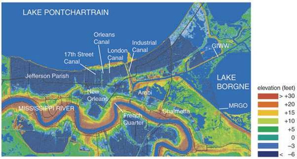
Indirectly the diversion of the river has cost those who profit from wildlife and fisheries, due to a loss of wetlands and their nourishment to shrimp, crawfish, clams and numerous fisheries along the Gulf coast.
Meet Robert Bullard who says:
"Katrina was not isolated. It was not an aberration, and it was not incompetence on the part of FEMA and Michael Brown and the Bush administration. This has been going on for a long time under Republicans and Democrats, and the central theme that drives all of this is race and class."
Visualize
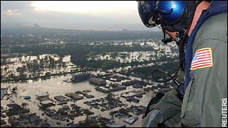
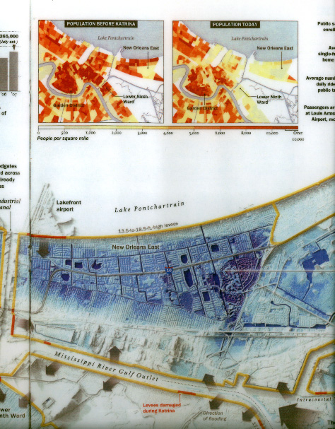
How did the policy for not maintaining levees lead to the destruction of 80 percent of the urban New Orleans area.
| Flood levels in New Orleans. | ||
|---|---|---|
 |
||
| High water mark | ||
The stained line reveals the water level when the levees failed.
The city resides in a bowl with it rims along the area of initial French, Spanish and Yankee settlement. The Creoles knew where the lowlands were inhospitable to development, but land tax laws, corrupt officials, and federal policy after World War Two encouraged the building in reclaimed swamps and along dangerously flood prone wetlands that formed the river's flood plain -- laid dry in drought years and submerged in periods of heavy flow.
Defining terms
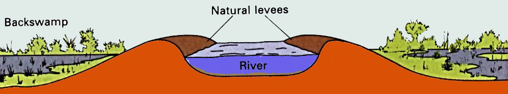
levee is a natural deposition or a constructed (artificial) edifice of elevated land running parallel to the channel of a river or water body. The term is French, in Holland it refers to a dike or raised wall of earth to prevent flooding by diverting water elsewhere.
subsidence is the loss in elevation of any terrain due to the removal of underground water or the oxidation of organic soils (muck) where the height of the surrounding area diminishes with respect to its original relief.
sea level rise is attributed to both the loss of water from land bound glaciers that melt and raise sea level or the subsidence of the land which sinks below sea level.
"dead zone" is an area the size of New Jersey of submerged anoxic waters off of the delta of the Mississippi River in the Gulf of Mexico.
Mississippi river watershed, drains about one third of the interior of the continental United States.
Nature's geometry, uses of to solve poorly designed systems that generate problems or disasters.
Coastal defenses policy
"Big campaign money buys special access. . . "
John Dean, Worse than Watergate. p. 76.
"Since 1879, the Corps of Engineers, at Congress's behest, has progressively lined the river with levees to prevent floods from damaging towns and industry. The river is now shackled from northern Louisiana to the gulf, cutting off the sediment supply. As a result, the plain just subsides below the encroaching ocean. As the wetlands vanish, so does New Orleans's protection from the sea."
Scientific American, "Drowning New Orleans," 2001.
". . . used in the Netherlands, these structures could be used, but are an expensive means, for protecting the nation's coastal cities and ports."
JVS
Coastal conservation
 Joseph Siry,
Essay
As the defense of a region erodes inhabitants will either move away or live at great risk. Wetlands provide an effective natural barrier against the enormous ocean that accounts for seven out of every three acres of this planet's surface. Often wetlands on islands are the indicator of a slowly rising sea level with respect to the coast. But if the pace of that change rises to the rate seen along the Louisiana Gulf coast the lesson is starkly etched on the eroding shore. One third of the nation's fisheries, one fifth of the its petroleum refining capacity,and one quarter of its natural gas are threatened in and along the Mississippi Delta.
As this article suggests, three years before the fateful August when Katrina went ashore due east of New Orleans, scientists, engineers, modelers, local, state and federal officials realized that the city and its million residents were at grave risk from flooding. Thus lack of forethought, fore warning, and preventive exercises were not contributing factors to the disaster of 2004. This case is almost the equivalent of a scared rabbit or deer caught in the headlights who freezes, unable to move and thus take effective action to avert the almost certain loss of life. What caused the lack of national attention to shoring up coastal defenses when so much was, is and remains at stake is more than a lack of political will, or venality of office, or official policies of denial. Beneath the loss of New Orleans in 2004 lies a confusion over values and a loss of confidence in our ability to know what is important and how to pay for protecting what we cherish.
Not human life, nor commercial investments, nor political clout was enough to adequately protect the the city and the case of New Orleans does not bode well for the plight of coastal America and its residents.
"Every twenty four minutes Louisiana loses one acre of land."
"In a study funded by the oil and gas industry Penland documented that the industry has caused one third of the delta's land loss."
"But in part because the levees and dredging prevent the river's last miles from meandering naturally, the mouth has been telescoped out to the continental shelf. The sediment just drops over the edge of the underwater cliff into the deep ocean."
". . . the Mississippi River may not carry enough sediment to feed multiple diversions. U.S. Geological Survey studies by Robert Meade show that the supply of suspended sediment is less than half of what it was prior to 1953 diverted mostly by dams along the river's course through middle America."
J. Siry
Sources
Mark Fischetti, "Drowning New Orleans," Scientific American, October 1, 2001. (www.sciam.com) version
 Lehr Report: Three Years After Katrina. 8-20-08.
Date: 29 December 2007
